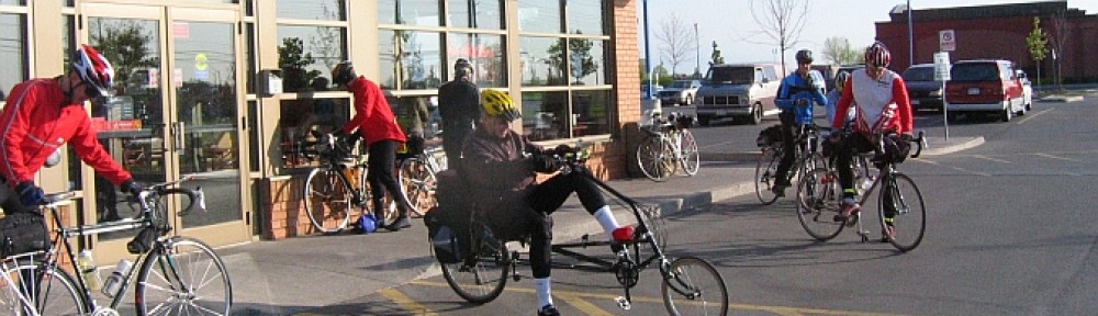
Ride report from Dave Thompson:
SR600k – what is it anyway ?
SR600k rides are defined as minimum 600k rides with minimum 10,000 meters of climbing. They have a couple of other organizational quirks — they are directly administered by ACP in France and they are also certified as Permanents from a RUSA point of view. One other key thing is that no support is allowed, not even at Control points. Because of the amount of climbing necessary, almost by definition you will be in remote areas without 24/7 service, so the Controls are mostly photo controls to show proof of passage. Time stamps at intermediate controls are not relevant, only start and finish. At start and finish you get a store receipt.
I need a plan
Planning for this ride was, in some ways, similar to planning for my first 1200k. With the amount of climbing, well spread out over the event, figuring out where I would be at any point in time was hit and miss. Given that most of the replenishment spots are not 24/7, I needed to know whether I’d be able to get food and water. I also planned for a sleep stop but needed to know if I was going to get there before checkout time!
Where and when I would hit various points along the ride would allow me to think about how much food and water I needed to carry and with some targets in place, know how I was doing during the ride.
So … I notionally figured out where a 10 mph average speed would put me along the course. I didn’t want to make this too complicated, so I didn’t allow any time at Controls other than the sleep Control, where I assumed 3 hours. With the course being 375 miles, that meant 37.5 hours + 3 hours = 40.5 hours vs the 50 hour limit. Knowing as I rode that I had a 10 hour cushion built into the times written onto my cue sheet for arrival at Control points would allow me to see if I was on track to finish in time. Trying to figure out anything more precise would be a waste of time, in my opinion.
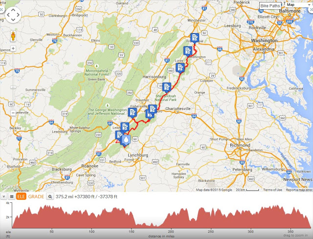
The following is from ridewithgps, plotting the route and showing the profile. That profile shows climbing of 37,380 feet but I know that this tool overestimates climbing, compared to, say, my Garmin results. However, my Garmin results show 35,294, so that’s actually not as far off as I’d thought ! This was a lot of climbing !
So what do I carry with me ?
Which bike to I bring ? What do I carry with me ?
Do I bring the new one with S&S couplers, front and back racks, front and back bags, etc. etc. or, in other words, handicap myself to the max ? The alternative is to bring the old Litespeed, rear rack only, bring the minimum to make the climbing easier. I did some weighing, figured out what else I’d be carrying (food, water, clothing) and yes, I could easily save 5 pounds or save even more if I went with minimum clothing and food on board, but to what end ? An extra 5 pounds of bike wasn’t going to make or break me, I didn’t think. A saved 5 pounds (notionally) in gear could very well cause a DNF due to major bonk or, more likely, hypothermia.
The weather predictions that I could see for the area led me to believe that I’d be dealing with high 80’s / low 90’s, temperature-wise. It seemed silly to carry a lot of clothing. Even the night-time temperatures weren’t dropping much below mid 60’s. However, I’ve been riding in that area and had the heat turn to hail almost in a heartbeat, and I knew that at best I’d be miserable, at worst, in trouble. I opted for light jersey, wool arm warmers, leg warmers (really thought that was silly, but they don’t take much space), skull cap, nothing in the way of rain pants or shoe covers.
It’s time to roll
This ride was tied into a trip to Reading PA, bringing our 7-year-old grand daughter home. We arrived in Reading on Tuesday; I drove to Front Royal VA on Wednesday, got my bike organized, planning for a 4am or thereabouts, start. I was up before 3am, had some food and coffee in the room, stashed my stuff in the car, as I’d be returning a couple of days hence, and set off. It was a comfortable low 60’s; I was also wearing my PBP reflective vest. Had it been a level ride, I’d have also put on my arm warmers but I knew that very shortly I’d have a long climb ahead of me.
I loaded up the ridewithgps course on my Garmin 705 but it didn’t appear on the map. Rats. It looked like it was loading properly but didn’t. There was nothing that I could do at that point; my cue sheet was in front of me anyway. We’ve done some investigation on the file and found two things — one is the sheer number of points, which I guess is because of all the twists and turns in the route — second is that it’s an invalid XML file. I will do some more on this, with Peter Grant’s help, so that we can let Gary Dean (route owner) know for future riders.
Not wanting to take a chance on using my iPhone for pictures and running out of power, I’d decided to purchase a small point-and-shoot to carry with me. For a little more than $100, I bought the Nikon Coolpix S33, which is waterproof to 30 feet, and a spare battery. I haven’t done much with it yet to see how it compares, in terms of picture quality, with smartphone pictures, but it did the job on this ride.
I filled my water bottles at the 7-eleven, got my receipt, took my picture and started rolling. My receipt showed 4:09 a.m.; I was rolling at 4:15, my official start time. The notional times written onto the cue sheet were based on a 4am start, so that was close enough.
Upward, ever upward
The ride profile shows a good bit of climbing at the beginning without any descending. Yup, that’s the case. Up, up, up from Front Royal on Skyline Drive. At the beginning of the Drive is a booth for collecting fees, as this is Shenandoah National Park. Needless to say, there was simply a sign saying “go ahead”, as the booth isn’t staffed at that time of day. In that first hour, I saw one car, clearly not enough traffic for them to pay for a staff.
The thing about the climbing on Skyline Drive and the Blue Ridge Parkway, is that the grades are manageable. They rarely top 9% and more typically in the 6-7% range. The climbs tend to be long, so you can settle in, which has it’s pluses and minuses. It does mean more time in the saddle, for me, as my style is usually standing up to handle rollers. It also means that I can end up grinding alone ever so slowly, after a time.
The other thing about grades like this is that they eventually give you the impression that there is more descending than ascending. Why ? Well, because 4-5% starts to feel like flat and 2-3% feels like downhill!
The extra time in the saddle also means something else — saddle sores. Yes, for the first time in my randonneuring, I finished a ride with an actual sore. I can often end up with tender spots at my sit bones but this time, first time, skin removed. I believe that this happened late in the ride, with my shorts wet from rain, but I’m getting ahead of myself.
I’d notionally expected to get to the first Control, Elkwallow Wayside, by 6:30, based on the distance of 24.3 miles. Adding 15 minutes to that for the later start would make it 6:45; I got there around 7am. So far so good. As expected, it wasn’t open so I stopped, rested for a minute, took my photo control picture, and rolled on. One down.
That first stage was beautiful. The sky lightened; the vistas of the mountains were beautiful; that one car that had passed me was stopped, occupant out with his camera and tripod, clearly setup to take pictures of the sunrise over the mountains. I too stopped and took a picture, wishing that I had a good camera with me but not wishing that I was carrying the extra pounds !
and the day goes on
The day carried on much the same, staying within an hour of the notional times, losing a little bit but not much until later in the day as I spent more time at Controls. My average rolling speed for the entire ride was about 10.5 mph, so not much different than predicted. Stopped time accumulated as I spent more time at Controls than I normally would but I knew that (or it seemed that) I had lots of cushion and took advantage of that.
Control # 3 at Big Meadows was well stocked and had sit-down food. I grabbed some cheese sticks, coffee and something else, I forget, which satisfied my hunger at that point.
Control # 4 didn’t have as much, as I recall, in convenience-store type items, but it also had burgers etc. All I wanted at that point was a big diet pepsi, feeling the need for some cold caffeine. The day was getting warmer but no where near as warm as I had expected. I’d hit this Control at 12:25 p.m.
From Control # 4 to # 5 there’s a significant descent and you then move off Skyline Drive and onto the Blue Ridge Parkway. Humpback Rocks Visitor Center is Control # 5 and it too was advertised as having food on the cue sheet but it’s more snacks than food; a selection of chocolate bars, little else. I was ok, had lots of food on board — almonds, cheese, filling stuff — restocked my water bottles and headed on. Where I had been about an hour behind plan at #4, I was now only 15 minutes behind plan on arrival. The extra descending accounts for that speed-up. 111.6 miles now in the bag, I’m getting close to being 1/3 of the way through the ride and rolling for almost 12 hours.
Control # 6 is in Buena Vista, having left the Parkway. There’s a significant descent to get there as its elevation is much lower. The roughly 70F riding on the Drive and the Parkway now shows what the elevation has done for the temperature as it’s like a furnace in Buena Vista. I’m ready for something more substantial to eat as it’s now 8pm against my plan of 7:30 (make that 7:45). The Exxon/Burger King is good for the Control, replenishing bottles, but the Subway across the road calls to me and I have a chopped salad, which I’ve gotten fond of. I probably spent 45 minutes or more at this Control. It’s getting dark and I’m prepping myself physically and mentally for the night ahead. I’m not in a hurry, no need.
The next stage to Glasgow VA is more typical riding, rolling, turns, some chipseal with loose gravel, traffic. Refreshing after all the long ups and downs, it’s also short, less than 20 miles, and I arrive just under an hour behind schedule at 10:10 pm. I knew that this would be the last Control with food & water before my night stop as everything from here to Raphine would be closed.
Control # 8 is next up, and it is up, back up to the Blue Ridge Parkway. It’s only 11 miles but takes extra time; I arrive at 11:45 vs 10:15 adjusted plan. It’s dark — yes, you’d expect that — no, it’s really dark. There are no lights. I find the sign where I’m supposed to take a picture but the camera doesn’t want to fire the flash or focus in total darkness. I fiddle with the menus, not something that I’d expected to do in total darkness; bugs are attracted to my bike headlight and mini light on top of my helmet. I probably could have used a flashlight at that point — I have a small single AAA flashlight that I’ve carried in a pocket before, but not this time. I eventually get the camera firing the way that I want, get my picture and hit the road again.
When I’d entered the Control, looking around for the correct sign for the picture, at one point I dropped the bike – not me, just the bike. I was up against a curb and didn’t know it. Drat. Luckily no damage but it really went down hard, over the curb and down on the other side. My front bag was open so a few things spilled out; luckily I retrieved and repacked.
Onward. The next Control would be my sleep stop at Raphine, 44 miles away. 2/3 of that is riding the Parkway, no traffic, quiet, then a very steep descent / hairpin turns down to Raphine. I wouldn’t know how steep that road is until the morning, when I’d climb back up ! I pulled into the 24/7 Pilot in Raphine at the intersection with I81, bought some food and drinks, piled those on the front of the bike and headed to my motel, just up the road. Having arrived at the Control at 5am vs my plan of 3:15, I’m still expecting to make it a three hour stop. I clean up, eat and drink, check email and facebook, sleep for an hour, take my time getting organized and having some breakfast, hitting the road a little before 8am, about one hour behind plan, but that’s ok.
Riding Day 2
Raphine is at mile 227.2, I now have 150 miles to go. I’m more than half-way finished as I start out again, roughly 28 hours on the elapsed time clock, a few hours less on the rolling clock.
On the way into Raphine, there had been a few drops of rain and I mentally had crossed my fingers, hoping to finish the “day” dry. I was successful, but I saw that it had rained overnight and The Weather Channel in the breakfast area at the Comfort Suites was showing lots of rain. Oh well, I’m prepared.
Getting back up to the BRP was going to be some work, I knew, from the descent the night before. Retracing my route, there’s a 4 mile climb. I didn’t realize until I hit it going up, that some of the up hits 20%. There’s no way that I could sustain that for so long without completely wiping out my legs. My bike, including water, gear, food, tops 40 pounds. That’s almost 1/3 of my body weight ! Furthermore, any climbing at that grade wasn’t much faster than walking. I admit it, I did some walking.
The other factor for that section was safety. Traffic was going up and coming down those hairpin turns.
Did I mention that it started to rain ? No, I didn’t. The heavens opened; dumping is a more appropriate description. It rained so hard that water was coming down the road in waves. It was basically timed such that it came down that way for the entire 4 miles. It was slow going, but, as I said, not much faster than riding.
Back on the BRP, I’m now retracing my route from the day before, except that the route diverts to Wintergreen. A one-mile, 15% grade downwards (yes, I was thinking about the trip up), it was lightly raining. Then there is a 2.4 mile climb at 15+ %, but it varies, so I’m walking and riding. It’s raining and there’s significant, albeit polite, traffic.
I had no idea that Wintergreen was a ski resort, well, year round resort. It’s a beautiful spot. The climbing (ugh) and the location (neat) and the food at The Market (Control) remind me of Whistler BC only on a much smaller scale. It looks pretty exclusive. http://www.wintergreenresort.com/
A fellow in a delivery truck recognized me from the road from Raphine to here. He comments he knows a lot of “younger guys” who wouldn’t attempt this. I say yes, I’m older and stupid :).
The Market is well stocked; typical resort stuff, not convenience store. I stocked up, sat down and ate something. I’d arrived at 11:20, about 1.5 hours behind my tracking time. I’m in pretty good shape.
Once back on the BRP, I’m retracing steps and photo controls back to ride’s end. I get to Loft Mountain, # 11, mile 295, about 2.5 hours behind tracking, at 4:35 pm. I’ve been taking my time. I’m expecting this to be my last opportunity to get food before the end of the ride. I order some “chicken tenders”, relax, spend more than 1/2 hour.
Big Meadows / Harry F Byrd, is at 323.8. I get there a little under 3 hours behind at 8:05 pm. Since my plan has a built-in 7 hour cushion, I’m in great shape. BM is now closed, but water is available. I stock up.
The last few hours on Skyline Drive has been like riding through an immense, spread out, herd of deer. They’re mostly tame, don’t mind me stopping and taking pictures even if I’m only 50 feet away. I can see why the bag limit for deer hunting in VA is 7, but of course they are protected here in the Park.
On one descent, a doe and three fawns run across in front of me. The last fawn stops, unsure what to do. I skid to a stop, barely one foot away. He/she decides to follow its mother. Whew. Hitting a deer of any size could certainly do me in !
Somewhere along here I have also seen my second bobcat running across the road. There’s really been little else in terms of wildlife — birds, deer being the majority.
The next Control, Elkwallow, is at mile 351. I’m almost finished. I’m about 2:45 behind schedule and expect to make up some of that time on the last leg, in fact, I expect to make up an hour on the last leg, with that long descent it will be a fast 24 miles. That was not to be …
I pull into Elkwallow and don’t recognize anything. In fact, I don’t see anything. Nothing. Of course I’d arrived here after dawn the day before so perhaps it’s completely dark ? No, that cannot be … I ride back out to the road and realize that I’ve pulled into Elkwallow Campground, not the Wayside, which is just up the road.
Into the Wayside, I take my picture. It starts raining lightly, so I put on my rain jacket, wishing that I’d instead brought my light jacket. Wrong. I hit the road again.
Where the heck am I anyway ?
About a mile out of that Control, now about 23 miles to the end, it starts raining heavily. I’m climbing and I run into fog. No, this isn’t fog, this is cloud. I’m in the clouds. It’s so dense that when in the middle of the road, I can’t see the sides. From one dash on the center line, I can’t see the next. I’m riding in a 6′ diameter pool of light. I have to point my light downwards more so that it shows the road and doesn’t just create a blinding white fog patch.
It cools off. I’m starting to get cold. There’s nowhere to stop and even if there were, I couldn’t see it. I’ve been riding the center line to stay on track. I’m forced to take off my jacket and put on my arm warmers. I also balance the bike while putting on my leg warmers. I’ve had the skull cap on for a while. I’m now wearing all my clothes, my only backup being an exposure sheet !
I stand up and ride, even though I’m going slowly. I generate more heat that way.
My Garmin loses the satellite, the cloud cover and tree cover (at times) are so dense. I have no idea what speed I’m riding, just know that it’s slow, riding the yellow line. I mentally think ok, 5 mph tops, this could take another 4-5 hours; I’m still ok but pushing it.
I start falling asleep, focused on that oh-so-little patch of road. I’m wandering all over, but I’m only crawling anyway. I’m going so slowly that the internal battery on the light has no chance to charge. The light goes off immediately if I stop, which I have to do occasionally. One time I stop, then start up not realizing that I’m riding across the road. The light comes on 1 second later and I almost ride off the road (it’s all downhill from there !).
This goes on and on. I haven’t seen any traffic since Big Meadows, 5 hours earlier. This could be someone’s definition of hell, endless. I’m ok. I stop a couple of times along the road, eat some cheese and almonds out of my bag; food can be such a comfort ! The stop breaks the monotony, keeps me alert.
I start descending. Soon I can see the sides of the road. I speed up, a little, not too much because vis isn’t all that great. I realize that I’m finally, finally on the big descent. I’ve got a few miles to go but the end is “in sight”, so to speak. The only thing accurate on the Garmin at that point is the time. Speed is back on; distance is wrong. Elevation is probably correct, but accumulated ascent is wrong. That will self-correct when I load the history file, but that doesn’t help me here. That doesn’t matter, I’m almost finished.
I roll into the 7-eleven and get coffee. I’m cold but more than that, I need a receipt. I stand in line. Who goes to 7-eleven at this time of night ? Only randonneurs know for sure. My receipt says 2:01 a.m., which puts my time for the ride at 45:46 against the 50 hour limit. I did not make up any time on that last, endless, completely surreal experience of the last stage. Every ride has it’s memories, and that one will surely stick with me, one of the strangest experiences that I’ve ever had on the bike.
Skyline Drive and the Blue Ridge Parkway are so pleasant to ride on. There is very little traffic, no trash, great roads for riding with a friend as you have an opportunity to ride side-by-side and chat. The roads are in good shape, easy on the tires and body. There are enough services, if you plan it out, especially on Skyline Drive. BRP is another matter — if you don’t leave the Parkway, there’s nothing.
Skyline Drive is by far the prettier of the two. There are innumerable outlook points, named vistas. BRP, on the other hand, is mostly treed in with only a few places where you can see over the trees.
Most of the time you are sheltered, so wind isn’t an issue. There were only a couple of times where you are exposed to the wind, and it was getting windy by the evening of the second day — I got a taste of that at Big Meadows.
I loved the ride. I would do it again. I highly recommend it. Randonnesia has set in already !